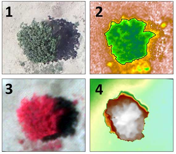
Forests And Rangelands

Asagro Services

Get a higher yield with Asagro analytics solutions

Satellite Data Acquisition

Modeling and Simulation

Analysis and Evaluation

Considering the emerging nature of this industry worldwide and the high potential for its implementation, ASAgro is striving to provide monitoring services in the forests and rangelands by utilizing its specialized knowledge in the satellites and agricultural analysis. In this regard, aerial and satellite imaging, along with the analysis of the resulting maps, can be used to monitor and investigate lands in the shortest possible time.

Best time to conduct analysis in forests and rangelands

Providable Services in Forests And Rangelands

Observing the overall condition of the area

The overall status of forests and rangelands, The status of construction and infrastructure, The condition of roads and drainage systems, The status of transmission lines, Monitoring of major events, Monitoring of hard-to-reach areas, Monitoring of margins, And more.
اینجا کلیک کنید

Phenology Monitoring

Studying the phenology of pasture plants and suggesting a schedule for livestock grazing.
اینجا کلیک کنید

Analyzing the status of the product

Analyzing the health status and growth trends in rangelands and forests.
اینجا کلیک کنید

Plant Monitoring

Monitoring vegetation cover in rangelands, calculating plant area and volume, assessing changes in rangelands from the past to the present, and predicting future trends.
اینجا کلیک کنید

The analyses conducted by ASAgro on Forests and Rangelands

1)Plant imaging 2)Canopy cover measurement 3)Tree health assessment 4)Tree height measurement
Assessing the health of rangelands in Alborz province.
Land use change map over time and future prediction
Land use map
"Zoning for prioritizing livestock grazing for suggesting the best time

مقالات مرتبط با رشد گندم

WeedDetection2

What Our Clients Say About Us

Contact Us

info@asauas.com

Scroll to Top